
from people.com
Recently, in conjunction with Batiquitos Lagoon Foundation, Preserve Calavera hosted a King Tides event at which we had speakers on climate change, historical changes to the coastline and sea level rise vulnerability plans. Afterwards, Bill Clayton, a retired Cal Fire Division Chief shared the following information with me:
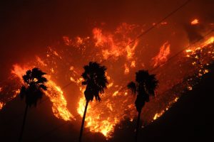
From 1889 until 2003 there was only one fire that exceeded 200,000 acres; The Matilija Fire, Sept. 1932, that burned 220,000 acres in Ventura County. In Sept. 1889 there was a fire called the Santiago Fire that burned parts of Orange, Riverside and San Diego Counties. There are conflicting reports that the fire burned between 250,000 and 300,000 acres, however no exact number is given due to various reporting standards and jurisdictions.
Between 2003 and 2017 there have been five fires that burned in excess of 200,00 acres.
1. Thomas Fire: Ventura and Santa Barbara Cos. 281,260 acres and destroyed 1063 structures. 17 deaths
2 Cedar Fire: San Diego County 273,246 acres and destroyed 2820 structures. 2 deaths
3. Rush Fire: Lassen County 271,911 acres and destroyed 0 structures.
4. Rim Fire: Tuolumne County 257,314 acres and destroyed 122 structures.
5. Zaca Fire: Santa Barbara County 240,201 acres and destroyed 1 structure.
In a period of 114 years from 1889 until 2003 there was one fire in excess of 200,000 acres, in a period of the last14 years there were five fires that were in excess of 200,000 acres.
I was the unified incident commander on the 2003 Cedar Fire. The source of this data is from Cal Fire statistical records.
And now, we’re seeing devastating mudslides and flooding in Montecito, CA. This is a huge increase in severe wildfires in the last 15 years.